Saturday, December 5, 2015

A Call to Mapping


Is there a stream of water that exists before we name it “river?” Is the world what we have labeled it to be? Are we?

This is how the poem, "A Call to Mapping," begins. I read the first half of it as part of my lightning talk at the 2015 U-Spatial Forum, on November 20th at Rapson Hall, University of Minnesota.The forum is a mash up of people using GIS or spatial technology in ALL different ways (from artist, Rebecca Krinke's beautiful "Mapping of Joy and Pain" project to another professor's mapping the surface of Venus.) It is mind-blowing and enriching to see the variety of work presented that is united by spatial thinking.

GIS Story Maps as a Theatrical Prop
I presented "River Journey High School Story Maps; Using GIS Story Maps as Part of Place-based, Art-led, Environmental Education." River Journey took place at River's Edge Academy Charter Environmental High School, where I worked with a collaborative team, of teachers, staff, and students to take a year-long "Earth Systems Journey" of water through their school, tracing the flows from their kitchen sink to the Mississippi River--upstream and downstream. The primary aesthetic composition of River Journey is the designed experience itself. But art is also used for theatrical props throughout. Although the River Journey GIS Story Maps serve many purposes in the project, it is their part of the composition of student experience that I focused on for this talk.  I highlighted three of their roles as part of what I call the narrative-aesthetic experience that engages participants with story through aesthetic interaction.

GIS Story Maps Narrative-Aesthetic Roles


1. Marking and Naming
I was interested, particularly for High School age students, in connecting them to their agency and power as map makers, as expressed in "A Call to Mapping" which I wrote as a meditation for myself about the project. For example, there is great significance in the simple act of placing a map pin at the confluence of the Mississippi and Minnesota Rivers and labeling it "B'Dote" after interviewing a Dakota band member about the supreme significance of this place to their creation beliefs. Marking and Naming a place on a map and telling its story is a ritual act of placing significance to a part of the landscape.

2. Virtual Aesthetic Understanding of the Land
It is important to the philosophy of River's Edge Academy and to the Earth Systems Journey approach to go outside and explore real places. Virtual exploration is not a substitute. However, an interactive GIS map offers perspectives that can't be seen from ground and these are not only knowledge-based in nature - they are also aesthetic. I remember working with a student as they paused from the tutorial on map creation to enjoy the pleasures of flying over and following the river in the satellite image. These are beautiful views that are a kind of primary aesthetic experience in themselves where one can wonder about the varying colors of the water, and the textures of the vegetation.

3. Vessel and Object of the Quest
As an Earth Systems Journey, River Journey is inspired by Joseph Campbell's concept of the Hero's Journey. This begins with a call to adventure, and is a quest for something. In fairy tales, the hero might seek a treasure and bring it home in a vessel. Knowing their final expression of their journey was to be an online set of story maps, made the GIS Story Maps into a key player in the journey; they were the vessel into which students would place their treasure to bring back to share with community: the story of their exploration of the value of the Mississippi River.


Sunday, October 25, 2015

Mapstories and more at AASHE

Detail from Mapstories, 2011
I'll be displaying Mapstories at the Minneapolis Convention Center Sunday-Tuesday, October 25-27 as part of the expo hall art exhibits for the Association for the Advancement for Sustainability in Higher Education (AASHE) annual conference this week.

Mapstories, 2011,  is a large, interactive, multimedia artist’s book. Viewers/participants explore the layers to reveal images of places where hidden paths of water connect a school on the map with the Mississippi River – the source and destination of the water that flows through the students’ classroom sink. The artwork was part of a participatory art-led environmental education project called Downstream/Upstream using a curriculum model developed by the artist called Earth Systems Journey. The map was installed at the students’ school in 2011 and grew during the project to include photographs taken by children, ages 4-6, while on their water journey.

I'll also be speaking about art and art-led environmental projects at AASHE. Monday, I co-present River Journey with other team members and talk about "Mapping Campus Connections:  Using GIS Story Maps as Part of Place-based, Art-led, Environmental Education." On Tuesday, I co-present with curator/moderator, Roslye Ultan and three other artists on "Art as Vital Agent in the Spiral of Sustainable Change."

Friday, October 2, 2015

Invitation to Exhibit Reception: We Watch the Stream Tuesday, October 6th

,,,Behind on blogging, and updates, but for now, I want to invite you to the closing reception for the exhibit We Watch the Stream: Impressions of River Journey. Here's the Info:


 June 15, 2015 – October 12, 2015
Commons Meeting and Art Space at Institute on the Environment, U of M
Reception: Tuesday, October 6th, 2015 from 4:00 pm to 6:00 pm, short program at 5:00 pm
R350 Learning & Environmental Sciences, 1954 Buford Avenue, St. Paul, MN 55108
Open Monday – Friday 8:30 a.m. – 4:30 p.m. Parking is available behind the building in the Gortner Avenue Ramp.

we watch the stream: Impressions from River Journey
Jonee Kulman Brigham with River’s Edge Academy
How do we learn to see the deep interconnections we have with the world around us? It is challenging when our language and social-economic structures divide the world into so many parts. Common maps divide the land by property or political boundaries. Multiple organizations manage different parts of the continuous stream of water that passes through our buildings in hidden pipes and unlabeled channels. Visibility and value are intertwined — unseen elements can easily be neglected. Through River Journey, students found the pieces of their water story and stitched them back together.
During the 2014-2015 school year, high school students at River’s Edge Academy participated in an art-led, environmental education project called “River Journey: Exploring the Value of the Mississippi River,” led by Jonee Kulman Brigham, design researcher, artist, and developer of the educational model. Students traveled from their school’s kitchen sink, tracing the path of water along upstream and downstream infrastructure, to reveal how they and their school are interconnected with the Mississippi River. Along the way, they met with community members, and engaged with water, infrastructure, poetry, reflective writing, and photography to develop an appreciation for the river and the water it provides.
The exhibit includes artworks and documentation of the River Journey project including photographs, maps, reflective writing, and objects used for water interactions. The project and exhibit is made possible through a fellowship from Institute on the Environment, and the support of River’s Edge Academy, many community partners, and Full Spring Studio.  
See website for more information at http://rea-river-journey.blogspot.com/p/exhibit.html

Wednesday, June 3, 2015

River Journey Closing Activities


Full Spring Studio is part of River Journey at River's Edge Academy, even though the project is mostly run from my role at the U of MN, through a resident fellowship at the Institute on the Environment. One of the roles of Full Spring Studio in River Journey is providing the aesthetic/art elements of the project. Many of these came to a closure today:

  • The poem written for the project was recited a final time, during a closing ceremony for River Journey.
  • The closing ceremony was enacted, with students and staff offering thanks to the Mississippi River for something that was meaningful to them.
  • And the display case for Journey Bottles was installed. 
The most meaningful part of this project for me, has been getting to experience and participate in the River's Edge Academy culture, and spend time with inspiring staff and students. That's what I offered in the closing ceremony,"I'm thankful to the Mississippi River, because it drew River's Edge to it's banks, and allowed me to spend time with all of you."

See the River Journey website for more information.

Monday, April 20, 2015

The Private Joy of Process


Friday, April 17, 2015
The preparation for an interactive project can be just as rewarding for me as the event itself. Last Friday evening, I was alone in a parking lot, happily tying bundles of tall grasses from the parking medians with twine, and then cutting the bundles, just above the new green tips of growth.

This was for a project coming up called "Braiding In" where I will lead an inter-generational art activity for members of a church to meditate on human/earth community. They will work together to braid last years' grasses together with bright, spring-colored raffia to make a decoration for the church garden.

The event will be one of many activities going on to honor Earth Day. The native grasses, are part of a sustainable landscaping strategy on the site and represent both the members' commitment to the earth, and also - in this project - the cycle of the seasons and the way new life draws from - and is folded into - life that came before.
Last year's native grasses
Tied with one string, the bundles collapse after cutting.
Tied with two strings,
the bundles stay together after cutting
Harvested grass bundles
Trimmed grasses, waiting for new growth.


Thursday, April 16, 2015

Flying Over

Flying Over, 12-10-14, Full Spring Studio
What is this? That's what I thought as I skimmed thumbnails of some photos from late last year. At first I thought it was from the plane when I took a trip out west, but it was the wrong date. Then from the pictures around it, I realized it was from the River Journey project, and the students' trip to the University of Minnesota to visit the John R. Borchert Map Library and learn about GIS story maps from U-Spatial.

Ryan Mattke, Head of the map library, had generously prepared some interactive map activities, and pulled out a suite of current and historical maps for the students to explore different views of the Mississippi River and the Twin Cities Area. In trying to photograph a sampling of what the students were viewing, I caught the map's protective film reflecting the ceiling lights. Now, this accidental image prompts a map-meditation for me to think about how hard it is to see the land directly: from the bottom up, the map maker has only traced and labeled what they want to see. And as we fly over, what of our own reflection further filters the view?

Wednesday, April 15, 2015

Recommended: Water Bar

Another highlight from the 'Once and Future' river symposium I attended and posted about last week, was to hear Shanai Matteson, of Works Progress Studio, talk about a project she and her partner Colin Kloecker (with other collaborators) created called Water Bar. Now - don't judge it by my own crude sketch here - they have beautiful images that capture the project at their website: www.water-bar.org

Since I wasn't sure about rights to reference their images, I made this sketch impression of the project, which actually helped me think about what the project means to me as a connection to the source of my own tap water: the Mississippi River.

I'd visited the mobile Water Bar at Work's Progress's River City Revue one summer, where the tap waters of local municipalities were served  up by water resource experts who poured a "flight" of samples for comparison. The expert bar tenders shed light on the flavors and the reasons behind the surprisingly noticeable differences from the different taps, but it was the participant's own experience of taste that was the focus. Can you tell the difference? Which one do you like best? What does it remind you of?

At the symposium, Shanai talked about some aspects of the project, which you can also see discussed on the website, especially themes of bringing awareness to the interconnected systems and people that bring us tap water. It seemed to me, that she and the website, tended to focus on the social-interactive aspects of the creation and final experience of the project - the "conversations and connections." I can see why, since this aspect is so innovative and well executed.

But another aspect of the project I think is also strong is the direct interaction with the water itself.
While drinking the water could be seen as a vehicle or prop to enable the social, technical, and ecological conversation - the conversation also enables the experience of the water. The whole premise of the tasting flight, the storied waters, and the evaluation card for writing notes, would probably elicit "deep tasting," whether all the same waters were poured or not, as participants stretch their sensory perception to try to ingest the interconnection.

Or at least, that is how I remember my own experience. While I want my water treated and clean,  I jump at the chance to have it weave me back into the world too. I want to see the river's waves in the cup, and maybe even a fish.

Tuesday, April 14, 2015

Power Basket

My fingers are sore this afternoon from doing some heavy duty basket weaving on a new project, called Power Basket. It is made with reclaimed household electric wire, and equipment from our remodel. I notice that I repeatedly return to coil-formed basketry - which I first applied in a large scale on Children's Nest Egg. Power Basket is surprisingly heavy, and it's just begun.


Friday, April 10, 2015

Size and Story: The Mississippi--Mighty, Malleable, Mother

Children's Nest Egg, 2007. Full Spring Studio
The Mississippi River symposium I've been attending this week and wrote about yesterday, concluded this morning. This afternoon, I find myself reflecting on the symposium in terms of the story of scale - the scale of water issues, the scale of human influence, and the scale of the Earth itself.   

Images from Children's Nest Egg (2007) run alongside this post, as prior art explorations on the theme of our size and place in the world.

One of the final symposium panelists was Kate Brauman, Global Water Initiative, Institute on the Environment, University of Minnesota. She said some things that illustrate the way we use facts to support narratives - or perhaps just trigger narratives by the way we express facts, whether intentional or not. She noted, for example, how when we say the Mississippi River is the third-largest watershed in the world - just how big that seems. And when we say that usable fresh water is a small percent of all the world's water, how small that seems.

Depending on the context of conversation, fresh water and the river are cast very differently in our story in terms of their scale, which I would argue, also implies different power relationships between humans and water. "Small" water, is conceptually fragile, precious, and needing of our care. While "large" water might represent abundance, a paternal/maternal sense, or in times of flood, a not-so-benevolent overtaking character. The scale of our relationships can also imply different kinds of response, and responsibility. In terms of problems like climate change, do relatively "small" humans adapt, whereas relatively "large" humans mitigate?

Several times throughout the symposium, speakers said that whatever we do, the river will survive and that the question is what we want to see the river be - what scenario do we want to play out. This stance, of humans as responsible designers of the future, seems to also have a shadow side to me -- a perception of ourselves as, what speaker and artist Mona Smith called, "puppet masters." We understand the humbling corrective to human presumption in that phrase, but isn't this also underlying the narrative of the "Anthropocene" which casts humans as the largest, most powerful character in the current story of the world?

Children's Nest Egg, 2007. Full Spring Studio
Near the end of the discussion, there was an exchange that contrasted the rhetorical question: "Do we want heavy metals in the river?" [of course not] with a deeply concerned response about how we could  even ask that question, about the river, "our mother." To me this was not only a cultural question of what is sacred, but also a question of how large we think we are as humans, and what that implies in terms of what questions are even appropriate to ask.  All members of the concerned community caring about the river in that room have mostly common aims, I believe, even as they have different methods, and stories. Not just the artists, but all in the room, work in the context of stories, explicit or not. I hope the exchange of this week makes our stories more complex, so that they help us see ourselves both large enough to take responsible action, and small enough to do so with great humility.

Thursday, April 9, 2015

Art and Science of Relationship and Meaning

A vessel for water, tobacco, gratitude, and commitment
I am so inspired by the symposium I'm attending this week called,
The Once and Future River: Imagining the Mississippi in an Era of Climate Change put on by the University of Minnesota, Institute for Advanced Study. It will take months to reflect on all the perspectives offered. You'll see why if you look at the speaker and topics list - from artists to water scientists to historians, with speakers from around the country and strong representation by Native American artists, advocates, and scientists.

On Wednesday night, the keynote speakers were Jim Rock, incoming Program Director, Marshall W. Alworth Planetarium, University of Minnesota-Duluth and Sharon Day, Executive Director, Indigenous People’s Task Force. Jim said something that struck me as extraordinarily useful for the interdisciplinary gathering focused on the river, and as an understanding to bring to other complex conversations. I may have jotted this inaccurately, but the gist was this: that Dakota science is first about relationship and meaning, and second about measurement and prediction, though all four can work together. I find it interesting that he included relationship and meaning as part of his idea of science, not just a precursor. This might bend up some people's ideas of what the word "science" means, but I found it very helpful to integrate the idea of meaning and relationship into science to begin the symposium's big questions to establish the idea that value, relationship and meaning is foundational to any conversation, even about scientific topics or about the academic study of perspectives on the river. The idea of relationship is not just another topic alongside others, but can be a permeating paradigm, and an experiential reality.

Embodying this, after their talks, Jim and Sharon, and others conducted a ceremony to initiate the symposium that included songs of water gratitude in several languages, a pouring together of waters from near and distant water bodies, and an offering of tobacco. So often in problem-solving discussions, what is sacred, or deeply valued is left at home, so as not to cloud the 'objective' discussion or perhaps to guard against the vulnerable open-heartedness that deep connection can produce. This entirely different approach of beginning with a shared experience of relationship and meaning, does not cloud, but instead guides the intellectual discussion. It is as if the ceremony invites our hearts, as well as our heads into the room, to give the conversation ethical and value-based grounding and to draw us personally inside the circle of our shared concern. We can no longer stand at the edge of the river, it has now washed over us and we are immersed. The ceremony is a sacred, functional, and participatory artwork, doing an essential job in the ecosystem of constructive conversation.

Update: The video of the symposium keynote is now available here.

Wednesday, April 8, 2015

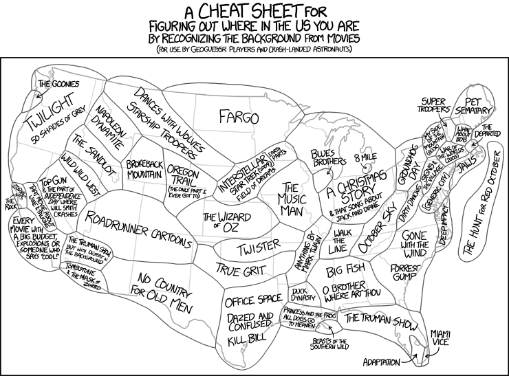
Enjoying: xkcd Map


I'm focused on story maps lately, so this xkcd map fits right in. ...From maps that tell stories, to stories [ala movies] that create a map (physical and mental) of iconic landscapes of the U.S.

Tuesday, April 7, 2015

Map as Stage Set: The Role of Maps in Downstream/Upstream, Part 1


"Mapstories" Full Spring Studio, 2011
Part of Downstream/Upstream
Learning from Physical Maps
I'm at an interesting point in the development of the Earth Systems Journey model for art-led environmental education. The first pilot, "Downstream/Upstream," was completed in 2011 with four to six year-olds, "April Showers, Storms and Flowers" was completed in 2013 with second graders, and I'm currently working on River Journey with a high school. One of the things that has emerged from the development of River Journey, is the great opportunity for using digital maps (or more specifically ArcGIS Online and Story Maps tools) as a vehicle for creative engagement and learning.

 But the use of maps in Earth Systems Journey (ESJ) is not new. Physical maps were an important part of many "props" in the first ESJ, Downstream/Upstream. And, in fact, the physical use of maps, as they support the participatory experience of ESJ, have the potential to inform the use of digital maps, so that they do more than provide a computer lab-based learning and communication function, but can also better serve the creative and experiential aspects of the journey.  This prior experience with physical maps can inform and inspire future uses of GIS story maps in several ways: recognizing its role as an important dramatic “prop,” interactive object, and record of the journey -- themes which I'll explore over several posts.


Detail from "Mapstories" Full Spring Studio, 2011
Map as Stage Set
and Call to Adventure

The 8x8 foot Mapstories (see images) shows the Twin Cities metro area in a collection of lift-the-flap map sections. It was constructed in the hall of the early learning center the week before the journey to create a sense of drama and anticipation. The map became a meeting ground for interaction. At the start of the journey, I gathered students around the map to launch the journey by showing where they (and their classroom sink) were on the map and asking, "Where does the water come from?" and "Where does the water go?" I also asked the children to help tell the story of water with all their senses and their camera and that their pictures would become part of the map, revealing the hidden path of water they discovered.

In one way, Mapstories was a stage set for participants as human actors in that it was a place for leaders and participants to launch and talk about the journey. The giant map, defined an area where significant parts of the journey itself took place, as well as a visual symbol of the journey that participants walked by every day so they could hold the idea of it in their mind. It was large enough, to create a setting or scene for interaction.

But Mapstories was also a stage set-in-progress, waiting for for a story of water that the children would help develop, and in that way it became part of the call to adventure itself. The map was the container for the "treasure" that the children would bring back. For in a "Hero's Journey," on which Earth Systems Journey is partly based, it is not enough for the hero to go out and find something they are looking for, (such as the source and destination  of their water in this case). Usually, in a Hero's Journey, the hero returns to community with something to offer, and a story to tell. 

In later posts, I'll explore how the role of physical maps as a stage set and call to adventure can inform the use of digital story maps in Earth Systems Journey projects.